Hiding out in the mountains of Pennsylvania near the town of Connellsville, there used to be a mining facility with its own town and railroad. It was known as Casparis. Now mostly owned and controlled by the PA Game lands with some private owners around the edges, it’s a treasure-trove of off-road trails that crisscross the mountains offering scenic overlooks, deep mud holes, and rocks to climb.
On this trip we had:
- Alex & John – Jeep Wrangler Unlimited Rubicon – C.O.R.E.
- Andrew & Cherie – Nissan Xterra – C.O.R.E.
- Aaron – Jeep Wrangler JK – Destination Adventure Overland
- Tyler & Vanessa – Jeep XJ (Red) – Destination Adventure Overland
- Josh & Eric – Jeep XJ (Green) – Destination Adventure Overland
It’s been many years since anyone from C.O.R.E. has been there. My last trip was a brief drive through the area in 2013 that nearly had us fall off a cliff. And during that trip we learned a good portion had been sold for logging and they had already started to clear away large areas. I thought that might be the end of being able to off road here. I’ve been meaning to go back someday but timing never worked out until now.
As part of the planning, I looked up the Casparis area to see if I could find anything recent; any indication of it still being open, or something clearly saying it was closed for good. I didn’t want to make the 3-hour drive just to find a closed gate. Other than the past C.O.R.E. trips there and some old news articles, I couldn’t find much. But then I found another club that’s local to the area who had published several recent videos of them exploring the area. Destination Adventure Overland (DAO) is a Pennsylvania based club that’s a lot like C.O.R.E. I reached out to them with some questions that they were happy to help answer. After a bit of good conversation, I asked if they wanted to join us for our trip and show us around. They said sure! So we picked a date that they could meet and take us on a tour of the area.
Since we had no idea what to expect as far as difficulty goes, we kept this closed loop. I reached out to a few fellow members about doing a small recon trip up there to see what the trails were like. Figured 3 rigs at most from our club would be ideal. If everything was good, we’d plan for a bigger trip later in the year for the club and any guests. Jendra and Andrew both accepted this challenge and planned to go with me. Unfortunately, Jendra caught a nasty cold and had to bow out last minute. Andrew and Cherie were still able to make it.
Our plan was to meet somewhat early in the morning at the local gas station and then head out to the trails. Our meet time was 9:30am with a roll out no later than 10. We found the folks from DAO waiting for us rearing to go. We had our introductions and got to see who was driving what. We established a plan to head to the mines first, and then they would take us up to the top of one of the mountains and then around one of their favorite trail routes.
The drive from Sheetz to the trailhead started bringing back so many memories for me. Personally, this was one of my favorite off road areas and I loved coming up here. I was getting excited to see how much had changed and how much was still the same.
The first section leading to the mines was the same as I remember. A gravel/dirt road with a few washouts and a small creek crossing. Nothing to really fear. We did find a new gate installed a fair bit up from the mines where we parked and continued on foot. Years back you could continue up to a small clearing with boulders in a circle marking the end of the vehicle trail. I guess they got tired of folks driving over and around them and installed a gate with signs saying no motor vehicles past this point.
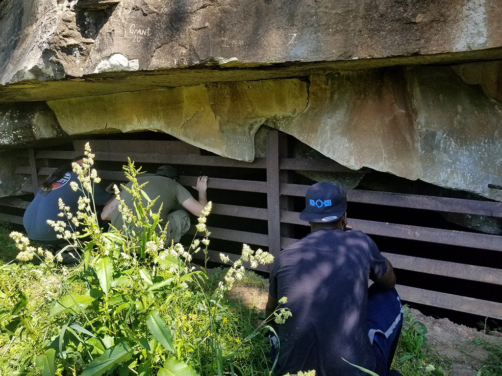
We hiked down to the old mine entrance and saw how much it had changed. If you didn’t know the history of the area, you would think this was just a small clearing in the woods left over from logging. The hill blocking off the entrances has been completely reclaimed by nature. There is a small path to the right that still leads up the top of the hill where brand new reinforced gates have been installed blocking entrance to the mines. No more chicken wire fences and poles in a lazy attempt to keep people out. They mean business now. So much for seeing inside the mines again. Still cool to go up there and peek in at least.

We hiked back to the trucks and headed back to the main path and hung a right to head deeper into the woods. A little bit down this road you pass the old dam and reservoir. Where the gravel ends, it becomes a very narrow rough dirt trail. So far this is all familiar and I know where I am. The next spot should be the three-way hill climb, right?
It turns out that’s closed by the Park Service now, as indicated by the dozen or so no motor vehicle signs nailed to every tree on the two “fun” ways up. The left option, which was always what we used to call the bypass, is still open and up we went. Next spot should be the clearing where all the trails start, right?
And again it was, but it was not the same as I remember. The area was familiar but looked so different. It felt like visiting an old theme park you hadn’t been to in 15 years. Some of the rides were still there but now they have different names, and there’s other rides in place of your favorite ones. From here on out, it was all new to me. There were 5 trails that I counted on our brief stop. Our DAO friends said we’d head off to the left and then follow a loop trail that will bring us back to this clearing. This will be interesting as all the old trails I remember were to the right.
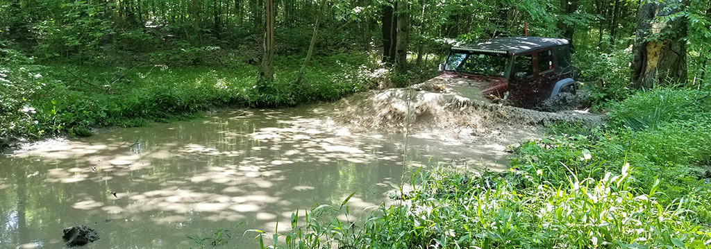
This is where the fun started. We ended up going down a section I used to call the deep dips that we’d do on the way out, on account there were these two massive mud holes that would eat a stock TJ if you let them. But looks like they got filled in a bit as this time it was just a few splashes. A bit more down the trail we turned left again to where I’d never been before and started heading up the mountain. This trail turned out to be really fun. DAO said we were heading to an overlook and a clearing we could use for lunch.
The trail followed along the ridge for a bit giving us some nice washouts and rock steps to contend with. We then came to a fork in the road where they said we can go up or straight for our loop. We opted to go up. This gave us a really long hill climb with several steps along the way to bounce over. The DAO guys told us to make sure we had enough momentum and to not stop. They all clawed their way up as Andrew and I watched. We all got up the hill no problem.
After this, it was business as usual to the clearing where we stopped for lunch. It was a perfect day for this, sunny with random clouds dotting the sky. The thick tree cover kept the area cool for us. During lunch we got to know our hosts and their club. They are a Pennsylvania-based club with a mix of vehicles that started back in 2017. They do overland and various camping events up and down the east coast. They also have a YouTube channel covering all their trips along with various how-to videos for off road safety and equipment installs. They were an awesome bunch and we shared a number of stories and about our past trips to Casparis.
After lunch we continued on to finish the loop and then head back to the main clearing where we started. This part of the trip decided to plague us with issues. First, we encountered a downed tree and none of us had a chainsaw. We only had a hatchet, so we took turns chopping away at it until it finally broke and we could drag the section out of the way. Then we decided to take a small detour to try some mud holes that DAO said were always deep. They weren’t lying. Tyler in the red Cherokee decided to give it a go. It was brave considering his doors were back at home. We almost had to fish him out when it bogged down halfway through. But with the gas pedal on the floor, and a lot of cheering he was able to climb out on his own. While we let the mud drain from his Jeep, I decided to try it as well. There is something to be said about lockers and the Rubicon setup, as I just waded through it without a fuss. I’ll admit it was deep and I had a pucker moment when the mud came up over my hood as I dove in.
We all laughed because Tyler’s Jeep was still dripping mud and asked who else was going to try it. With no takers we got moving again only to stop again after a tree limb decided to jump up and rip Josh’s rear brake line apart. Having no brakes going down a hill off road is a quick way to need a change of pants. Good thing the e-brake still worked. We pinched what was left of the line to stop the leak and topped the reservoir off. The idea was to at least get off the trails where a tow truck could get to us if needed.
We slowly made our way back to the main clearing with a different vehicle up front in case Josh couldn’t stop and needed to push on someone to do so. Once there, we all crawled under to investigate what happened. One of the guys called the auto parts store in town and found that they had a replacement brake line on the shelf. They said they would run in to town and grab it and come back to install it before they all headed home. At this point it was late enough in the day that with this repair, there wasn’t going to be any more trail riding for the group. We offered to help but they said they were okay from here. With that, Andrew and I said our farewells and headed out with the one vehicle heading back to town. Now for the 3 hour drive home.
What a day. It was awesome to be back at one of my favorite areas. Definitely planning to go again and explore some more. It seems like no matter how many times I go, there’s always a new trail to find and map. The trails here have never been “easy.” I’ve seen stock TJ’s lose parts. I’ve seen modified rigs have to get winched out. Today showed us that it can still be the case. Casparis still offers a trove of off-road challenges with amazing views and scenery. It’s still a well-kept secret of the Pennsylvania mountains.
Track
Profile
No data
No data
No data
No data
No data
No data
Duration:
No data
Trail report written by Alex Hinson. Pictures courtesy of Alex Hinson, Andrew and Cherie Taylor. Video courtesy of Destination Adventure Overland.