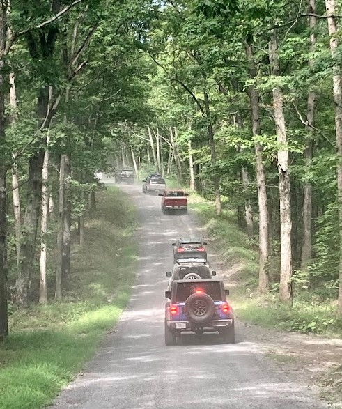
On an amazing late summer day in August, we decided to make a visit to Green Ridge State Forest in Flintstone MD for a day ride through the lush forest roads.
Attendees:
- Jendra – Toyota Tundra
- Ben – Toyota 4Runner
- Miguel & Alex – Lexus GX470
- Toby – Jeep Cherokee
- Ken – Ram 1500
- Jeff & Barb – Land Rover Defender
- Andrew – Nissan Xterra
- Cliff & Anne – Jeep Grand Cherokee
- Matt – Yukon Denali
- Ali & KP – Land Rover Defender
- Dawn – 4Runner
- Dawn’s Matt – Ram 1500
- Steve – Nissan Frontier
- Kevin – Jeep Wrangler
- Shawn – Jeep Cherokee
Green Ridge State Forest is a beginner friendly favorite for the club, with its amazing scenic overlooks, mild forested trails, and dispersed camping sites throughout. In years past, the forest roads were hard packed dirt, with the occasionally rutted out section, but nothing a Subaru Outback with stock suspension couldn’t handle. That made it a great beginner trail, as well as a relaxing and scenic ride for off-road veterans as well! This trip also provided a bit of a shakedown run for some folks in the group with recent upgrades to their vehicles, specifically new wheels and tires for Steve’s Frontier and Jeff’s Defender.

In the recent trip to Wolf’s Den, both vehicles went down with flat tires, victims of being more street oriented tires. Both vehicles reported that the newer smaller wheels and bigger tires resulted in a more comfortable and compliant ride off and on road, and were certainly trail ready!
This trip, we met at our usual meetup spot at the ranger station headquarters at 28700 Headquarters Dr NE, Flintstone, MD 21530. There we did our drivers meeting, and made our walk down to the Green Ridge overlook, which is a beautiful scenic view, overlooking the valley below.
We got back in our vehicles, fired up our GMRS radios and locked into channel 19, and headed out to the start of the trail, starting down 15 Mile Creek Rd. To our surprise, it looked like the management folks had flattened and graded most of the roads within the forest. Green Ridge was certainly not challenging in the past, but it was even flatter and smoother now. While this presents an even less challenging day for us, it makes the park more accessible to more standard vehicles, which is also a good thing.
This being said, it was pretty easy going, as we made our way towards Point Overlook for a lunch break. Luckily for us, it was empty when we arrived, making room for our 15 vehicles!
From here, we set up in the grassy area near the overlook for lunch, and just relaxed next to the amazing view for a bit.
From there, we ventured down into the valley towards the southeastern end of the forest, which provided a scenic contrast to the upper ridgeline. Here we were surrounded by tall trees and valley walls, snaking our way down alongside the various creeks that trickle into the nearby Potomac River. This part of the forest was less developed, and presented the occasional small mud puddle or rain induced ruts that we made our way through. Still nothing challenging, but fun nonetheless.
After making our way back westward, we headed to the second of our scenic overlook views, near group campsite G7. This is a nice small pull-off from the trail, and also marked the entrance to another loop in the park that had been closed off for a few years now. It was an optional route for us on this trip, and if it was open we would investigate it. Unfortunately it turns out it was still closed, so we continued on with our ride westward towards Twigg Road.
Twigg Road was a stark contrast to its past condition. It is now a completely flat and gravel graded path, whereas it used to be a bit rutted and worn out, with larger mud puddles and parts that caused a small bit of suspension articulation. Now, like the rest of the forest, it was smooth and graded with gravel.

As we wrapped up, we made our way northward to the entrance where we came in to wrap up the trip. It was a beautiful day, with perfect temperatures and clear skies! Thank you to everyone who made it out and made for a perfect day on the trails!
Track
Profile
No data
No data
No data
No data
No data
No data
Duration:
No data
Trail Report written by Jendra Rambharos. Pictures contributed by Jendra Rambharos, Ben Dunkerton, Dawn Keslar, Andrew Taylor, and Ken Kyler. GPS track provided by Jendra Rambharos.