
What a trip!! Potts Mountain Jeep Trail has kind of been my white whale ever since we decided to not complete it back in 2014 which is the last time the club attempted it. Back then my wife and I were much newer to off-roading, and we had only done our suspension lift slightly before the trip so were still feeling it out. Then-club-President Larry Pope decided for the group that our vehicles probably could not have done the middle portion of the trail so we did both ends but never the middle. I’ve wanted to make it back one day and complete the trail ever since.
As far as I know this is the most difficult trail on public land in Virginia. On the CORE Trail Rating system we anticipated this trip would be a 7-8. For that reason only experienced drivers and/or very capable vehicles were encouraged to attend. Armor and winches were a must. Up for the adventure were the following:
- Andrew and Cherie Taylor – Nissan Xterra
- Jendra Rambharos – Jeep Wrangler JKU
- Kirk Adams – Toyota FJ Cruiser
- James Bullock and Sara – Land Rover LR3
- Brian Middleton – Jeep Wrangler JKU
- Sergey Revashev and Ilya Aluker – Jeep Wrangler JKUR
- Steve Schueler – Nissan Frontier
Most of us decided to camp at the nearby Meadow Campground, part of Wilderness Adventure. It was a great find by Kirk’s wife Melissa which we grew to appreciate more and more all weekend. Those that were camping arrived Friday night and stayed through till Sunday morning.
Saturday morning the camping group convoyed out together to meet Brian, Sergey and Ilya at the trailhead around 9. As was planned before the trip Steve hopped in with Jendra for the day. After airing down in the parking area at the lower trailhead, and then a quick drivers meeting, we were off! We immediately crossed a stream and then started going up.
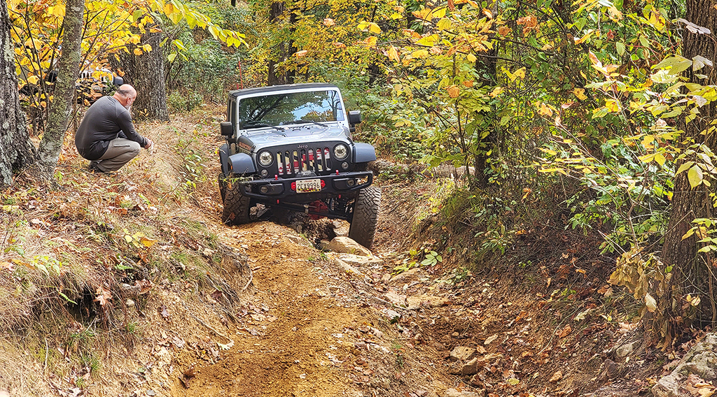

About 2 miles in we hit our first real rocks. It was an optional deep washout with rocks and an uphill off-camber climb. The bypass put you on the high side of the washout on a narrow shelf tipped toward the washout… We all chose to do the washout and made quick work of it. It was a great quick dip into the difficulty the trail had in store for us.
Not too far after that we got to what I thought was “the main event” which was the area locals had told us back in 2014 was called The Valley. This section of trail has a rock drop in from this direction and then a 200 yard section that can’t be bypassed full of rocks with an exit on the other end. We got out and walked this area and came up with a plan. I entered first without any drama, closely followed by Jendra and Steve, Kirk, and then James. Once in the valley I moved on toward the exit. I got a little hung up on a big rock on the way out but was ready to pull winchline if needed. I knew there was a lot more trail ahead and everyone came into this trail expecting to pull winchline.
Kirk gave it more gas and popped over the obstacle that hung me up, but winched just after it on another less dramatic rock. Jendra also needed winched at the exit to the valley, as did James. Brian and Sergey however, thanks to bigger tires, getting to watch everyone in front of them, or maybe just because of more skill hopped up over the exit without incident!
Shortly after we decided to pause for lunch. We knew there was a meadow somewhere ahead but decided to pull off at the first real clearing we found in the woods. Lunch was good and a great chance for us to all take a deep breath, we had made it through The Valley.
Shortly after lunch we happened upon the meadow. While it was plenty big for many groups to eat at simultaneously we all agreed that our foliage covered spot on this clear day had been a good pick.
Next was a small series of rock gardens, mostly optional. It was here that Kirk got hung up and scared us all with the only mechanical damage we had to address all day. What sounded bad turned out to be just a slightly bent diff skid making the diff skid bolt hit the pinion flange bolt as the driveshaft rotated. While Kirk crawled under to loosen and bend parts back into place a group of buggies passed us going the opposite direction.
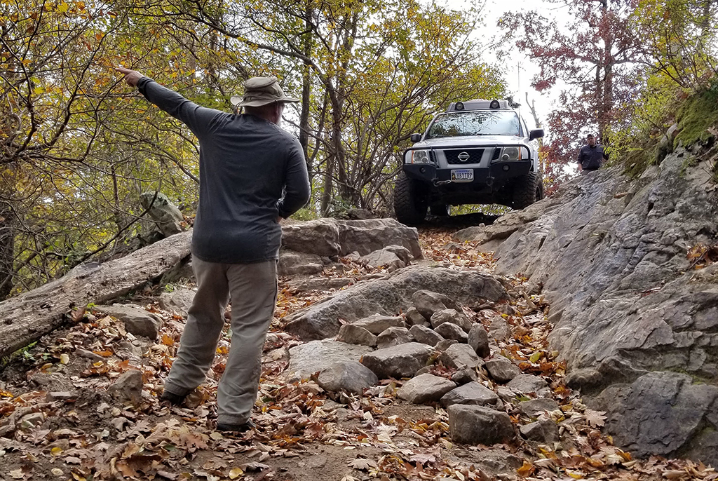
After that we got to another split in the trail. We had two options with one full of medium sized and loose rocks and the other with fewer but larger rocks. Considering the time of day, and not knowing what else lay ahead, we decided to go on the first option which we considered easier, although it was definitely not trivial to go up. Our reward at the top was an overlook on top of a big rock on the side of the trail.
It was at this point that Cherie and I realized that in 2014 we had not made it back to the “exit” side of The Valley in 2014 on our second day but instead had missed roughly 1.5 miles of trail in the middle. Larry had mistakenly identified the section near the overlook as the backside of The Valley but now we knew there was far more trail between these points. No matter, more just interesting to know.
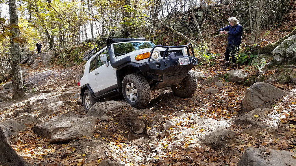
From then on we were starting to feel the lateness in the day. We didn’t know how many more obstacles were ahead, just how many miles remained. So we opted to take the easier route at the remaining optional sections (some of which would require a buggy for sure). There were several more rock gardens though that I look forward to driving in the future.
The one place we did pause for was this large wedge shaped rock that we got pics on in 2014. This time I drove up on it for a pic and then decided I thought I could come down off the steep side. Much to everyones surprise I did so without incident… which meant almost everyone else had to also try it! Great photo op for all, but Jendra and Brian found out that the breakover angle on their Jeeps was just a hint different from Kirk and I’s vehicles and they both came to rest on their belly pans and had to be winched off. Sergey came off the rock with more speed, and maybe those sweet 37in tires also helped, but he did not need to winch. James decided to save the rock for another day.
This was basically our last noteworthy obstacle. It turned out the last 2 miles of the trail was basically just a Corolla-rated dirt road through the woods. Something to keep in mind for the future when pacing ourselves.
We got to the end of the “trail” portion at what some maps call the mid trail crossover and collectively took a celebratory sigh of relief. We had made it!
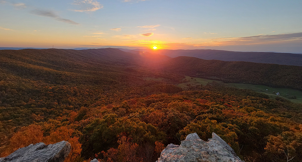
Considering the time most of us decided to quickly head to Hanging Rock Trail and try to get to the rock in time to enjoy sunset. This route would have us driving ½ of the remaining 7 miles that the National Forest Service considers part of the “trail” although this part of the route is on Potts Mountain Jeep Road rather than Potts Mountain Jeep Trail. Anyways, semantics aside, we made it to the outcropping just before sunset and were treated to quite the view.
The details surrounding our drive back in the dark and airing up weren’t that interesting other than don’t trust your GPS navigation out there… We got back to camp at almost 9pm and the campground staff were very kind and offered to cook us dinner even though the kitchen had closed an hour earlier. Most of us took them up on the offer and were treated to some great burgers and mac and cheese while enjoying some live music.
Sunday morning and the inevitable pack-up always comes too soon. But we all had a blast. Everyone had a great attitude on the trip, got through without any major damage, and everyone but Sergey ended up on a winchline at one point or another. It was a challenging trail, but I think everyone agreed we would need to come back again, and this time not wait anywhere near another 7 years.
Potts Jeep Trail
Profile
No data
No data
No data
No data
No data
No data
Duration:
No data
Route to Hanging Rock
Profile
No data
No data
No data
No data
No data
No data
Duration:
No data
Hanging Rock Hike
Profile
No data
No data
No data
No data
No data
No data
Duration:
No data
Trail Report written by Andrew Taylor. Pictures and video clips contributed by Andrew and Cherie Taylor, Brian Middleton, James Bullock, Jendra Rambharos, and Sergey Revashov. GPS tracks and highlight video provided by Andrew Taylor.